Cami de ronda blanes lloret
The barcelona ring road
We leave in front of Plaça de Catalunya. We follow the Passeig Marítim (Passeig de Cortils and Passeig de Vieta) in a northeast direction (NE), towards the seaport. It’s a very pleasant walk, with areas with trees and clearings along the main road. There is no marking or signposting.
We pass in front of the Blanes Sailing Club and, a little later, through a pine forest and leave the passage – in this place, it is called de la Mestrança -, and take the Pas de la Mestrança, a narrow street, with stairs. We take Esperança street, and go to the right, going uphill, in the east direction (E).
We will follow the GR92 signpost, in the direction of the cove of Sant Francesc, starting the coastal path. We go along a path between the reixat of farms, downhill. We arrive again at the sea, we will see the Roc des Viver in front of us, and we approach, along the coastal path, in perfect condition, to the cove.
It is a wide cove of sorra; with zone of restaurants at the foot of the coastal path. We follow the cemented path, where we will see signs of connection with the GR92 to 1 qm. We follow the coast; we pass through the middle of a path between the rocks, until the path makes a turn (it is a zone of esllavisades), and we go through some steps and we get away from the sea line.
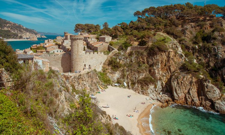
Camí de ronda tossa de mar
Blanes is the first town in the province of Girona, coming from Barcelona, and Sa Palomera, that rocky promontory linked to the beach by a narrow isthmus, is granted the grace and honor of marking the beginning of the Costa Brava.
Following the marks of the GR, we enter an urbanization built on very steep terrain, which forces us to overcome three long and steep flights of stairs to reach the highest part and from there continue to Santa Cristina. These stairs have become a bit heavy. Perhaps because that was not what we intended to do …. But that’s the way it is!
Just behind the building there is a beautiful esplanade presided over by a large centenary pine tree, where every July 24, the day of Santa Cristina, a fishermen’s lunch is held in honor of the saint, in which the typical stew is eaten.
We return to the GR and in a few moments we reach a large traffic circle where is the entrance to another botanical garden: Santa Clotilde. From there we take direction to the large Platja de Fanals. We go all the way to the end of a beautiful promenade, and again a detour forces us to leave the water. An access closed by landslides…
Camí de ronda mapa
Estaba planificando un viaje a España a finales de agosto, y me encontré con algunos blogs que decían que el camino del norte de Cala Bona (Cala de Sant Fransesc) en Blanes, anteriormente cerrado, es ahora accesible hacia el norte y eventualmente lleva a la zona de Lloret?
La única fuente oficial que he leído sobre este nuevo camino es en el periódico catalán Diari de Girona, pero no creo que diga explícitamente que el recién restaurado Cami de Ronda lleva a Lloret; sólo dice que ha sido reparado.
Si este camino es realmente accesible y conecta las dos ciudades principales, los caminantes ya no tienen que tomar la carretera interior sin vistas… el nuevo camino parece estar justo sobre el océano. ¿Alguien sabe de la nueva construcción?
Podría haber sido nuestro blog de senderismo (www.costabravaliving.net). Oímos que el camino se estaba extendiendo más cerca de la costa y fuimos a visitarlo en febrero, pero el camino seguía cerrado. En marzo de 20 varios informes dicen que el Cami De Ronda está ahora reabierto, pero creo que es un tramo relativamente corto y todavía tienes que subir a la carretera después – aunque una mejora definitiva.
Ruta del camino de ronda
Estaba planificando un viaje a España a finales de agosto, y me encontré con algunos blogs que decían que el camino del norte de Cala Bona (Cala de Sant Fransesc) en Blanes, anteriormente cerrado, es ahora accesible hacia el norte y eventualmente lleva a la zona de Lloret?
La única fuente oficial que he leído sobre este nuevo camino es en el periódico catalán Diari de Girona, pero no creo que diga explícitamente que el recién restaurado Cami de Ronda lleva a Lloret; sólo dice que ha sido reparado.
Si este camino es realmente accesible y conecta las dos ciudades principales, los caminantes ya no tienen que tomar la carretera interior sin vistas… el nuevo camino parece estar justo sobre el océano. ¿Alguien sabe de la nueva construcción?
Podría haber sido nuestro blog de senderismo (www.costabravaliving.net). Oímos que el camino se estaba extendiendo más cerca de la costa y fuimos a visitarlo en febrero, pero el camino seguía cerrado. En marzo de 20 varios informes dicen que el Cami De Ronda está ahora reabierto, pero creo que es un tramo relativamente corto y todavía tienes que subir a la carretera después – aunque una mejora definitiva.